The link between mountains and conflict is long established. Starting from the
military perspectives of Sun Tzu and Clausewitz, mountainous regions have been presented as being difficult
to traverse; they can be defended by smaller forces; they can also be difficult to hold (depending on the type of
mountainous terrain). Bringing the research forward, such regions have been related
to border disputes (Hommaire de Hell, 1847: 299-300; Aron, 1966: 203; Smith, 1995: 4, 11); can
facilitate guerilla warfare (Che Guevara, 1961: 29-32; Fearon and Laitin, 1999: 19; Buhaug and
Gates, 2002); rebels can hide in such regions (Sambanis, 2002; Cunningham et al., 2005);
governments may not be concerned about losing such regions if there are no readily extractable
resources (Fearon and Laitin, 1999: 28; Toft, 2003: 42). Conversely, mountain passes may be
strategically important (Toft, 2003: 42); ethnic minorities may be more likely to experience conflict
if they live in such regions (Fearon and Laitin, 1999).
Recenty, several authors have quantified the relationship between terrain and conflict. It is the argument of this research that there are issues with existing research for two reasons: i) it is state-centric; i) it depends unnecessarily on a mountain binary.
This new research deals with these problems by creating new methods, software and data, in order to re-examine some of the claims made in the literature.
Disaggregating from the state
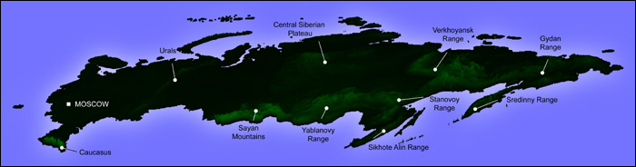
Existing research on mountains and conflict often depends on the state as the primary unit of analysis. Consider the following three dimensional image of Russia, generated by new technology created for this research:
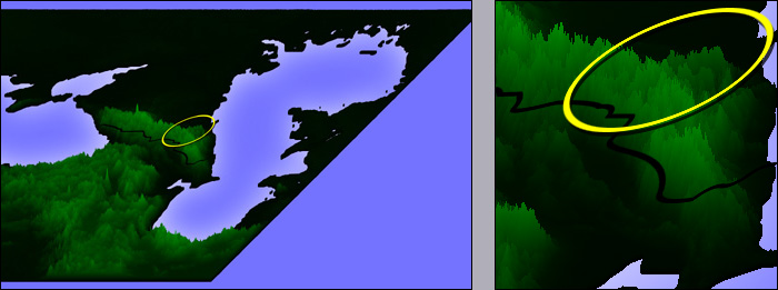
Gerrard's (2000) mountain dataset finds Russia to be 14.2 per cent mountainous. In isolation, this is not problematic. Yet when we try to understand conflicts at a sub-state level, this does become a problem. Chechnya, for instance, is rather more "mountainous," as is shown in the next diagram (the circle indicates the PRIO/ Uppsala v. 3-2005 identified conflict zone).
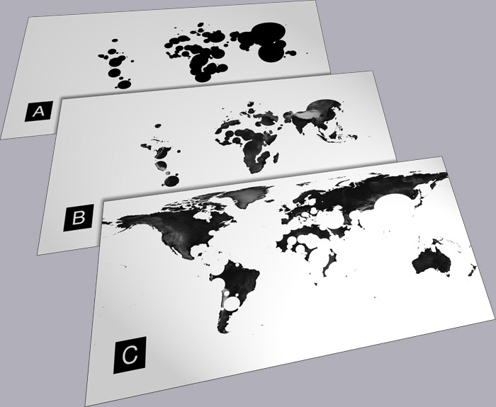
It is necessary, therefore, to disaggregate from the state. However, it is also necessary move beyond a mountain binary. The next diagram shows the ways in which NASA data can be combined with PRIO/ Uppsala data to do this.
Details on the methods employed here will be published in a forthcoming paper.
What is a mountain?
The literature on this subject is extensive; this would be an extremely long web-page if a review of such definitions were presented here! Gerrard (1990, 2000) provides the most comprehensive wrap-up.
The point here is that there is no a priori mountain definition; mountain definitions are always a posteriori. By way of example, in the UK, the Department for the Environment, Food and Rural Affairs (DEFRA) found it necessary to define the word "mountain," as part of right-to-roam legislation.
As such, the
Countryside and Rights of Way Act 2000 states:
`"mountain" includes, subject to the following definition, any land situated more than 600
metres above sea level;... "mountain, moor, heath or down" does not include land which appears to the appropriate
countryside body of improved or semi-improved grassland'
This definition is very interesting, but entirely irrelevant to conflict researchers. Whether a land-mass includes "improved or semi-improved grassland" cannot be of any consequence. This is, of course, perfectly natural: DEFRA had their own reasons for defining "mountain." Yet it is the argument of this research that definitions of mountains always come with some degree of baggage.
This becomes more apparent when we consider the issue of metricisation. The choice of 600m as the threshold of a mountain is interesting. 600 is, of course, a nice
round number: more pleasing than, say, 609.6m. The figure of 600m was originally settled on by
the Ordnance Survey; this was the nearest round number metric equivalent to their original figure of
2,000 feet (the actual metric equivalent being 609.6m). Again, of course, 2,000 is also a round
number: a convenient human rounding with no other purpose than making the number easier to
remember and more aesthetically pleasing. There is no "scientific" reason for 2,000 feet being the
threshold any more than there is for 1,993 feet being the threshold. Choosing 600m as the threshold
of mountains means a double rounding has occurred: the first in Imperial measure; the second in
metric. Curiously, this double rounding brought a new mountain into existence: Black Combe in
the English Lake District (presented at the top of this page). One of the last atlases to give elevation in feet is the Philip's Navigator
Britain atlas. It lists Black Combe as 1,969 feet: 31 feet short of the old Ordnance Survey
definition of a mountain. Yet 1,969 feet converts to 600.15m: 15 centimetres over the metric
mountain limit. Indeed, most modern atlases list Black Combe as having an altitude of 600m.
Black Combe, then, could be regarded as a "metric mountain." Two factors to consider in creating
a mountain dataset appropriate to conflict, then, are: i) rounding of numbers for aesthetic reasons;
ii) inclusion/ exclusion of territory due to metricisation.
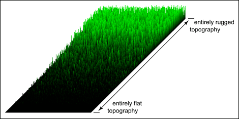
This research, then, avoids a definition of "mountain" altogether. Instead, it creates a "spectrum of ruggedness."
By conceptualising a ruggedness degree, it is possible to solve the problem of mountain inclusion/ exclusion: this gives us a continuous figure, rather than a binary one. Moreover, this method also permits disaggregation from the state: it now becomes possible to focus on individual conflict zones.


 but he does do